On this page
Part of Map Making Tools
Travel
The Travel tool shows how long journeys take across your map. Click where a journey starts and choose how it travels over land: on foot, by wagon or by fast mount, and in which season. The land is coloured by the days it takes to reach, a line marks the edge of each band of days, and the information bar gives the time to the point under the pointer and back. Shift+Click draws the quickest way there. Rivers and the sea are crossed by boat and ship, whichever way over land you choose. Climbs are slower than descents, ships sail faster with the wind than against it, and winter closes the high passes and the frozen seas.
Like History, Travel is for exploring a map, not a step in making it. It sits in the Explore stage of the rail and no Next leads to it. Nothing on the map is edited while it is open, and leaving it shows the map as before.
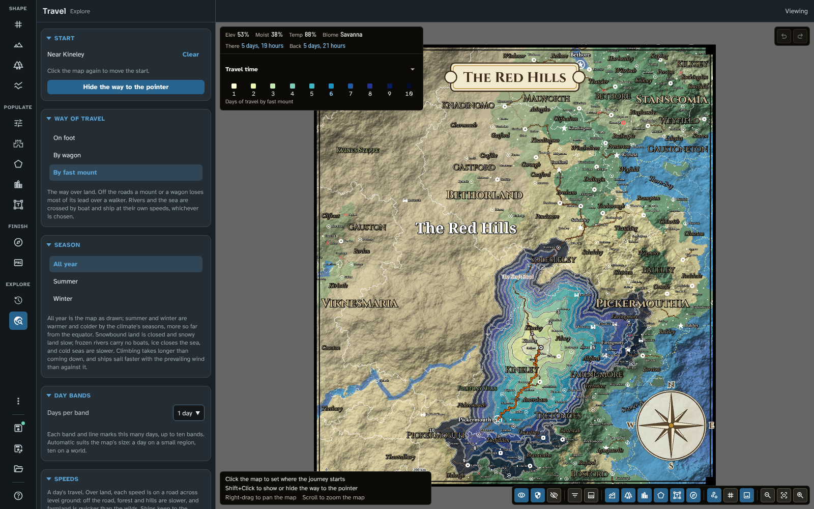
Travel on the regional map, by fast mount from Kineley in 1-day bands with the region fills off, and the way to Pickermouth drawn to the pointer.
Before you start
Travel works on any map, but it is most useful on one with routes:
- Roads, sea routes and river trade routes are the map's own routes, by their transport (see Routes and pins). Routes made by Generate and routes drawn by hand count alike, and a route you delete no longer counts. Without routes, every journey crosses the wilds and every crossing of water is by small boat.
- Farmland is quicker to cross than the wilds. It comes from the last Generate run (its cleared land), so a map that has not been generated treats all of its land as wild. A regional map carries its parent's routes, which count, and a copy of its parent's run, whose cleared land it uses until it is generated itself. The villages and lanes of a fill-in (see Fill in) don't change the farmland, and lanes don't count as roads.
The first time the tool opens on a map, it works out the map's travel network, which takes a moment ("Working out the travel network…"). It does so again after the terrain, the climate or the rivers change.
The panel
Start
Click the map to set where the journey starts. A click on a place (within a short distance of its pin) starts there, since a journey nearly always starts at a place; anywhere else, it starts at the point you clicked. The panel names the place nearest the start ("Near Ashby"). Click the map again to move the start, or Clear to remove it.
Show the way to the pointer (or Shift+Click on the map) draws the quickest way from the start to the pointer as it moves; press it again (or Shift+Click again) to hide it. The way is hidden each time the tool opens, and a Shift+Click never moves the start.
A start that is snowbound or in ice in the chosen season goes nowhere, and the panel says so: choose another start or season.
Way of travel
On foot, By wagon or By fast mount: the way over land. On a road, each goes at its speed (see Speeds). Off the roads, a mount or a wagon loses most of its lead over a walker, and farmland is quicker than the wilds:
| Off the road, on open level ground |
In the wilds |
On farmland |
| On foot |
half the road's pace |
80% of it |
| By fast mount |
30% |
60% |
| By wagon |
15% |
half |
Forest, marsh, desert and the like, and hills and mountains, slow every step off the road further, the steepest and roughest ground most. Hills slow a road too, but far less.
Climbing takes longer than coming down: every way adds an hour for each 600 m it climbs (Naismith's rule, over a six-hour day of travel), a wagon twice as long, and coming down adds nothing. So a road up a pass is slower than the same road down it. Across a world map, whose cells are far apart and its slopes between them gentle, this changes most whole journeys by a percent or two; it shows most on steep roads.
Season
All year, Summer or Winter. All year is the map as drawn; summer and winter are warmer and colder by the climate's seasons, more so far from the equator. In each, against the map's Freezing threshold (see Biomes):
- Snowbound land (below freezing) is closed, and snowy land (just above it) is crossed at half pace.
- Frozen rivers (below freezing) carry no boats; the way along them is by the bank.
- Ice closes the sea and lakes (below freezing), and cold seas and lakes (just above it) are up to 30% slower, the most near freezing.
The same rules hold in every season, so on a map with cold highlands some snowy land is slow all year, and pack ice on a polar map is closed in summer too. On most maps it is winter that closes the high passes, so the bands stop short of the mountains and the way goes round them. Travel shows ordinary travel, not travel with special gear, so a city in the mountains can be cut off in winter.
Winds: a sailing ship is up to 25% faster sailing straight downwind and up to 40% slower straight upwind (tacking), with the prevailing winds of the map's climate (the easterlies and westerlies of its latitudes, which also carry the rain and its shadows; see Biomes), whatever the season. A small boat is half as affected.
Maps made before version 4.3.0 keep the travel times they had, without climbs, winds or seasons, until you generate them again, and the panel says so in the Season section's place (see Updating to 4.3.0). A regional map follows the map it was cut from: generate the parent again and cut the regional map again, or use Clone as new and generate the copy.
Day bands
Days per band sets how many days each band of colour, and each line, covers: Automatic, or 1, 2, 5 or 10 days. Ten bands are shown, so a band of 2 days shows journeys of up to 20 days. Automatic suits the map's size, by its longer side: a day for a map under 700 km across, 2 days under 1,500 km, 5 days under 4,000 km, and 10 days for a larger map. The panel says what Automatic chooses ("Automatic (5 days)").
Speeds
A day's travel for each way, in the map's unit (see New map):
| Speed |
Preset (km a day) |
Used for |
| On foot |
30 |
Walking, on a road across level ground |
| By wagon |
25 |
A wagon or cart, on a road across level ground |
| By fast mount |
60 |
A rider, on a road across level ground |
| River boat, downstream |
60 |
Along a river trade route, with the current |
| River boat, upstream |
20 |
Along a river trade route, against the current |
| Sailing ship |
150 |
Along the map's sea routes |
| Small boat |
40 |
At sea away from the sea routes, and on rivers with no trade route |
Change a speed for this map in its field; Use the presets puts every speed back. The speeds are saved with the map.
- Ships keep to the sea routes. Away from them only small boats are found, so a long sea journey pays only from a port on a route.
- Going aboard takes time: finding passage takes a few hours at a town's harbour, and two days elsewhere on the coast. Coming ashore takes none.
- On a river with no trade route only small boats are found, so a boat goes no faster than a small boat, downstream or up.
- Each way is timed as it is travelled: going up a river is slower than coming down it, climbing slower than descending, and sailing against the wind slower than with it, so the way back can take longer. The information bar gives both.
Export this journey
Export image saves the map as the tool shows it, through the same dialogue as the Export tool. The image is named with the way of travel, the season and the start ("Westmarch, on foot in winter from Ashby").
The map
While the tool is open and a start is set:
- The day bands colour the land by the time it takes to reach, palest nearest the start and darkest furthest away. They cover the land only; land beyond the last band is not coloured.
- A line marks the edge of each band, numbered once with its day. The numbers turn round the start from band to band, so they do not stack.
- A mark shows the start.
- The way to the pointer, when shown (Shift+Click), is drawn from the start to the point under the pointer, each stretch in the colour of how it is travelled: orange over land, green by river boat, purple by ship or boat (the colours of the Trade layer).
- The map's own regions, routes, pins and labels stay as they are, so the bands read against the roads that shape them.
The information bar gives the time to the point under the pointer (There) and from it back to the start (Back): hours under a day, then days and hours ("2 days, 5 hours"), or a dash where no journey reaches. The Travel time legend below it shows the bands, each named by its last day, with the band under the pointer picked out, and the way of travel and season ("Days of travel on foot in winter").
The map controls:
- Thematic layers: the day bands are drawn in the colour layer's place, so the colour layers are set aside while the tool is open and come back when you leave it. Opacity sets how strongly the bands cover the map. Trade can be shown beside them.
- Regions: region fills tint the bands; switch off Fills to see them clearly.
The way of travel, the season, the speeds, the band width and the start are saved with the map, so the tool opens where you left it. The 3D view never shows travel times.
How the times are worked out
The times come from the same model of the land that Generate uses to place towns and roads, so they explain the network a run builds. The model divides the map into cells: on a world map, the generator's own cells about 25 km apart; on a regional map, where those would be few, finer cells about 10 pixels apart. Each step between cells takes a time from its ground, its climb, its route (if any), the season, the wind at sea and the speeds, and the quickest way to every cell is found from the start, and back to it. The bands and the time in the information bar blend between cells, so they change smoothly.
Tips
- Compare On foot with By wagon: a wagon is quick on the roads and very slow off them, so its bands stretch along the roads.
- Draw a road with Routes and pins and see how it changes the bands: a new road counts at once.
- On a world map, choose 10-day bands to see how long it takes to cross a realm; on a small regional map, 1-day bands show a day's travel from a town.
- Lower Opacity in the Thematic layers menu to see the terrain under the bands.
- Compare Summer with Winter from a mountain town to see which passes close.
- Point at a far port and compare There with Back: the prevailing wind can make one way days quicker.
Related: History, Routes and pins, Generate, Map Canvas, Export