On this page
Part of Map Making Tools
Labels
The Labels tool gathers every label on the map in one place. Pins, routes and regions each have a label of their own, which follows its owner's name; you can also place standalone labels anywhere on the map, for seas, mountain ranges, notes and anything else that has no pin, route or region. Name natural features finds the map's seas, mountains, forests, rivers and the like from its terrain and names them for you. Here you place, move, turn and size labels, and change how they look.
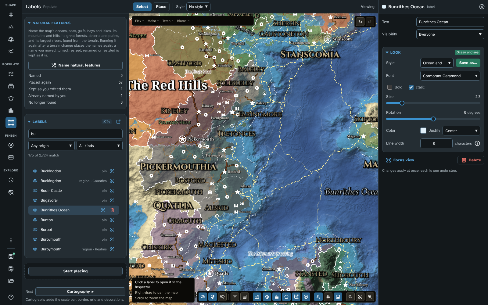
Labels, searched for "bu": standalone and owned labels, each owned one with what it belongs to, and Bunrithes Ocean in the inspector.
The panel
The panel has two sections: Natural features, then Labels.
Natural features
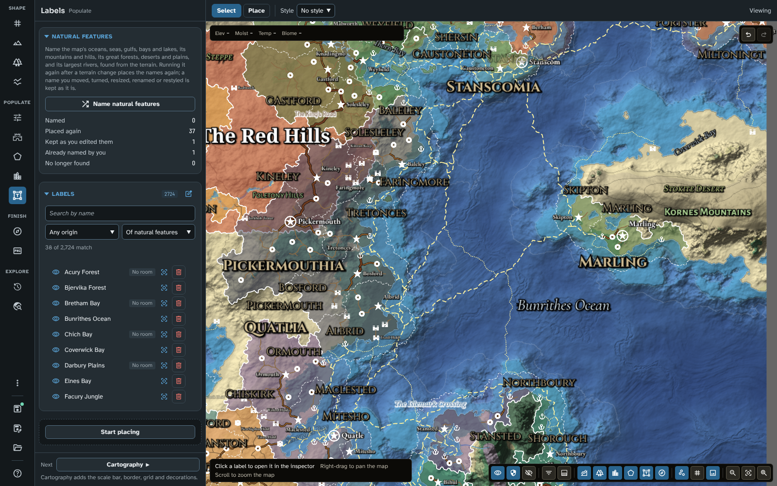
The Natural features section after a run, the list showing the names it gave, and some of them on the map east of the continent.
Name natural features finds the map's natural features from its terrain and gives each a standalone label:
- Water: oceans, seas, gulfs, bays and lakes.
- Relief: mountain ranges, hills and highlands.
- Land: great forests, jungles, deserts, steppes, tundra (named as barrens) and plains.
- Rivers: the largest rivers by flow, about a dozen on a world map.
Each feature is named in its kind's form ("Grey Sea", "Sea of Morn", "Gulf of Ashby", "Lake Tass", "Brenn Mountains", "Oldwood Forest", "River Wend"), in the language of the people living there, or the map's Default name style where no one does (see Generate and Cultures). No name is one the map's labels already have.
Each label is placed inside its feature, turned to follow it where the feature is long and narrow (a river along a straight stretch of its lower course), in one of six geographic label styles: Ocean and sea, Gulf, bay and lake, River, Mountains, Hills and highlands and Forest, desert and plains (see Label styles). The first run on a map adds the styles the map lacks.
Running it again (after a change to the terrain, say) looks for each feature's label from the last run:
- a label you have not changed is placed again on its feature, keeping its name;
- a label you have moved, turned, resized, renamed or restyled is kept as you left it;
- a label whose feature is no longer found is kept, so you can delete it if you no longer want it;
- a feature you have already named yourself, with a label in its group's geographic style inside it, is left alone;
- a river that a custom river with its name shown follows for at least half its course is left to the custom river's own name, and an earlier unchanged label of it is taken away (see Rivers and faults);
- a new feature is named.
The run takes a few seconds, is one step of undo, and its counts show below the button until another map opens: Named, Placed again, Kept as you edited them, Already named by you and No longer found.
A regional map's copies of its parent's feature names are your own labels there: on the regional map, Name natural features leaves a feature alone where one of them lies inside it.
The Water label style: the first run on a map made before version 4.2.0 replaces the old Water style with the geographic styles. Labels that used Water keep its look, as Custom, and the panel says how many there were. A Custom label says nothing about what it names, so on that run the features they name are named as well: delete whichever name you don't want. Give a label of your own one of the geographic styles, and later runs leave its feature alone.
Labels
The Labels section shows how many labels the list holds. It lists every label on the map by name: the standalone labels and the labels of pins, routes, regions and custom rivers. An owned label shows what it belongs to beside its name (pin, route, river, or region · its layer).
Above the list, a search field and two filters narrow it: Search by name, Made by (Any origin, Generated or Hand-made) and Kind of label:
- All kinds
- Standalone
- Of pins
- Of routes
- Of regions
- Of rivers: the names of custom rivers (see Rivers and faults), shown or hidden.
- Of natural features: the names Name natural features made, moved or not (they are standalone labels too).
- With no room: the names that are not drawn because there is no room for them among the others (see Where names go).
Natural features' names count as Generated, since the map made them, so Hand-made lists only the labels you placed yourself. While a filter is on, the list says how many labels match ("12 of 2,784 match"). A name with no room also has a No room badge on its row.
Click a row to open its label in the inspector. Each row's actions are:
- the eye, which cycles the label between visible to everyone, visible to the GM only, and hidden (an owned label's eye hides the label, not its owner);
- Focus view, which zooms the map to it;
- Delete, after asking (standalone labels only: an owned label goes with its owner).
In a studio less than 1,400 pixels wide, a row's actions show only on the row you point at, the row with focus and the chosen row, over the end of its name, so the names keep their room.
The section's title also has Select items for mass edit (see Mass edit).
Below the list, the state block starts and stops editing (Start placing, Stop placing), and Next goes to Cartography.
Every change is one step of undo.
In v3 the panel had separate lists for automatic and custom labels. They are now one list, with its filters to narrow it. "Custom" labels are now called standalone labels.
The bar
- Select: click a label to open it in the inspector; click away, or press Escape, to close it. Nothing is placed or moved.
- Place: place and move labels on the map (see below). Choosing Place starts editing; choosing Select stops it.
- Style: the label style the next standalone label gets, or No style (the map's label defaults). Label styles are managed in Styles and icons.
A label's text and look are changed in its inspector, not on the bar.
Labels on the map
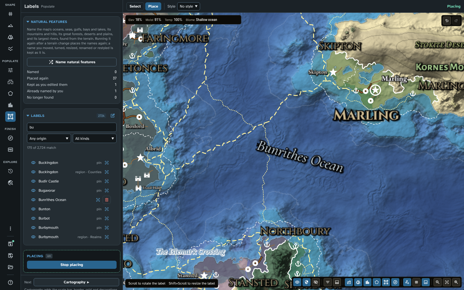
In Place mode, Bunrithes Ocean held and turned with the mouse wheel; the hint lists what a held label can do.
In Place mode:
- Click the map to place a standalone label. It is called New label, takes the bar's style, and opens in the inspector with focus left on the map, so you can type its text there or keep placing.
- Drag any label to move it.
- While you hold a label, scroll to rotate it (5° a notch), or Shift+Scroll to make it larger or smaller (in the same steps as its Size slider).
- Double-click a label to open it in the inspector.
In Select mode a click on a label opens it, and nothing moves.
Where names go
With Avoid overlaps on in the map controls' Detail menu (the default), names are placed so they don't cover each other, the pins or the decorations. A pin's name starts at the edge of the pin, on its right, and moves round the pin if that place is taken; a region's name finds a place inside its region; a route's name sits above or below its line, half way along if there is room, else nearer one end. Capitals and cities are placed first, then realm names (which always show), then the rest. See Avoid overlaps.
A custom river's name is placed as a natural feature's river name is: along a stretch of its course long and straight enough for it, turned to follow it, nearest the river's middle first.
A natural feature's name (see Natural features) is placed with the others while you have not changed it: at the place fitted inside its feature or a little beside it, keeping inside the feature where it can. A river's name can sit on any fairly straight stretch of its river, turned to follow that stretch. Once you move or change a feature's name, it stays where you put it.
A named route is placed before places' names, so they go round it: a route of your own with any name but the default "Route", or a generated route once you have renamed, edited or locked it. A generated route that keeps the name it was given, and a route still called "Route", are placed with the other routes, after the places.
Names keep clear of the scale bar and the decorations (see Names and decorations).
Names keep to the map: a region's or route's name is moved just inside the edge, and a pin's name goes to the pin's other side rather than off the map. With a border on (see Cartography), they keep clear of the border too. A place beyond the map's edge, in the margin the canvas shows round it, keeps its name off the map.
A name with no room is not drawn. While you are editing labels (in Place mode) it shows faintly where it would go, so you can drag it into a place of your own; a label you have dragged keeps its place. Which names show at all also depends on the map's Detail level and on the label styles ticked in the map controls' Labels menu (see Map Canvas).
The inspector
Each change in the inspector applies at once and is one step of undo (a text field applies on Enter or when you leave it, a slider when you let go). Double-clicking a slider puts back the value it had when the inspector opened. Escape closes the inspector.
A standalone label
The header shows the label's text and label.
- Text and Visibility (Everyone, GM only or Hidden).
- Look: the label fields (see below).
- Focus view and Delete.
A label of a pin, route, region or river
The header shows the owner's name and label · its kind. An owned label's text is its owner's name, so the inspector says what it belongs to (The label of the pin, route, region or river and its name) and offers Go to and the name, which switches to the owner's tool and opens the owner in the inspector. To change the text, rename the owner.
Then comes Look, with the label's own Visibility among its fields, so you can hide a label and keep its owner. There is no Delete: the label goes with its owner.
The same label fields also appear in the Label section of a pin's, route's, region's or custom river's inspector; both edit the same label.
Place automatically: a pin's, route's, region's or river's label you have moved by hand stays where you put it, whatever moves round it, and its inspector says so. Place automatically lets the map place it again (beside its pin, along its route or river, or inside its region, clear of other names where there is room), keeping its look, as one step of undo. It is offered only for a label you have moved. A regional map scales a moved label's place with its zoom, so this is the way to hand such labels back to the regional map's own placement. Mass edit of pins, routes, regions or rivers does the same for many at once, in its Position row (see Mass edit). A standalone label's place is always its own.
The label fields
- Style: the label style the label follows, or Custom. Save as… makes a label style from the label's fields and gives the label that style. Changing a styled field by hand sets the style back to Custom.
- Font: chosen from a list grouped by kind, each name shown in its own face (see Fonts).
- Bold and Italic. A font without a bold or italic face shows the control greyed out, with a tooltip saying so (for example "Sora has no italic"). The label keeps its setting, and is drawn regular (or upright) in that font and bold (or italic) again in a font that has the face.
- Visibility (owned labels only, here).
- Size (0.2 to 5).
- Rotation, from -180° to 180°, with 0° level.
- Colour and Justify (Left, Centre or Right).
- Line width (characters) wraps a label onto more lines once a line would be longer than that many characters; 0 means no limit. A character is the width of a "0" in the label's own font and size, so a label keeps the same line breaks when you resize it or change its font. Most letters are narrower than a "0", so a line usually fits a few more letters than the number you set, and words are never split.
Fonts
29 fonts come with the module, so a map's labels look the same in Foundry and on the web. The Font list groups them:
| Group |
Fonts |
| Studio faces |
Atkinson Hyperlegible, Sora, Barlow Semi Condensed |
| Book serifs |
Alegreya, Alegreya SC, Cormorant Garamond, EB Garamond, Spectral |
| Old print |
IM Fell DW Pica, IM Fell DW Pica SC, IM Fell English |
| Engraved capitals |
Cinzel, Cinzel Decorative, Marcellus SC |
| Calligraphic |
Almendra, Almendra SC, MedievalSharp, Uncial Antiqua |
| Blackletter |
Grenze Gotisch, Pirata One, UnifrakturMaguntia |
| Handwritten |
Kalam, Tangerine |
| Sans serifs |
Alegreya Sans, Alegreya Sans SC, Josefin Sans |
| Other scripts |
Noto Naskh Arabic, Noto Serif, Noto Serif Hebrew |
Between them they cover Latin, Greek, Cyrillic, Devanagari, Arabic and Hebrew. In Foundry the list also has This world's fonts, the fonts your world provides (Foundry only).
A font is downloaded only when it is used (or shown in the list). Several fonts have no bold face (the IM Fell fonts, Marcellus SC, Almendra SC, MedievalSharp, Uncial Antiqua, Pirata One and UnifrakturMaguntia), and many have no italic.
Noto Serif is the default font for new labels. If a map names a font that isn't available (a Foundry world's font opened on the web, say), its labels are drawn in Noto Serif, a notice on opening the map lists the missing fonts, and the font list shows the font's name followed by (not on this host). The label keeps its own font, so it is drawn in it again wherever that font exists.
Label styles
New maps start with fifteen label styles: Realm, Duchy, County, Capital, Settlement, Place, Note, Road and Sea lane, and the six geographic styles for natural features:
| Style |
Look |
Names |
| Ocean and sea |
Cormorant Garamond italic, large, pale blue |
Oceans and seas |
| Gulf, bay and lake |
Cormorant Garamond italic, pale blue |
Gulfs, bays and lakes |
| River |
Cormorant Garamond bold italic, small, light blue |
Rivers |
| Mountains |
Alegreya Sans SC bold, grass green |
Mountain ranges |
| Hills and highlands |
Alegreya Sans SC, smaller, grass green |
Hills and highlands |
| Forest, desert and plains |
Alegreya SC italic, pale yellow-green |
Forests, jungles, deserts, steppes, tundra and plains |
The greens set the land's natural features apart from the creams and golds of places and realms; both are among the colour picker's preset colours.
Generate uses Realm, Duchy and County for the regions it makes, and Capital and Settlement (through the pin styles) for its places. Name natural features uses the geographic styles. A label that follows a style changes when the style does. Label styles are added, edited, renamed and deleted in Styles and icons; a pin style can name the label style its pins' labels start with.
Mass edit
Standalone labels can be restyled several at a time. Press Select items for mass edit in the Labels section's title: a tick appears on each standalone label's row (owned labels have none; restyle those through mass edit of their pins, routes or regions), with Select all and Select none above the list. Tick the labels you want (Select all takes every standalone label matching the list's search and filters), then press Mass edit (its count shows how many are ticked), or Delete to delete them after asking, as one step of undo. Press Select items for mass edit again to stop choosing without changing anything; changing tool does the same.
The label style, font, Bold, Italic, visibility, size, colour, justification and line width can be changed together; each label keeps its own text and rotation. See Mass edit for how the dialogue works.
Tips
- Hide a label you don't want players to see with its eye, or set it to GM only, to make a player map and a GM map from the same map.
- To make every sea name look alike, give them a label style and change the style, rather than each label. The geographic styles do this for the names Name natural features gives.
- To rename a natural feature, type its new name in the label's Text: the label is then kept as you left it whenever the action runs again.
- At world scale many feature names have no room; the With no room filter finds them, and a closer Detail level or a regional map shows more.
- An owned label's text is its owner's name: rename the pin, route, region or river to change it (Go to takes you there).
- To let Name natural features leave a river you have already named with a label of your own, give that label the River style; or delete it and show the river's own name, if you drew it as a custom river (see Updating to 4.3.0).
- If names are hard to read on a regional map, try a larger Symbol size in the map controls' Detail menu (see Map Canvas).
Next: Cartography
Related: Routes and pins, Regions, Styles and icons, Map Making Tools