On this page
Filroden's World Map Builder
Filroden's World Map Builder is a system-agnostic cartography tool. It runs as a module in Foundry VTT, and in any browser at fwmb.filroden.com, with the same tools in both.
It builds a world from a seed: the land, its climate, rivers and biomes, and then the people who live on it, with their towns, roads, realms, cultures and history. You can edit all of it by hand, and cut regional maps from the world at finer and finer detail.
In Foundry, maps are saved as journals in a compendium. On the web, they are saved in your browser, and a map can be exported as a JSON file and imported into either version. Because the terrain is procedural and your edits are kept as a history of strokes, a saved map stays very small.
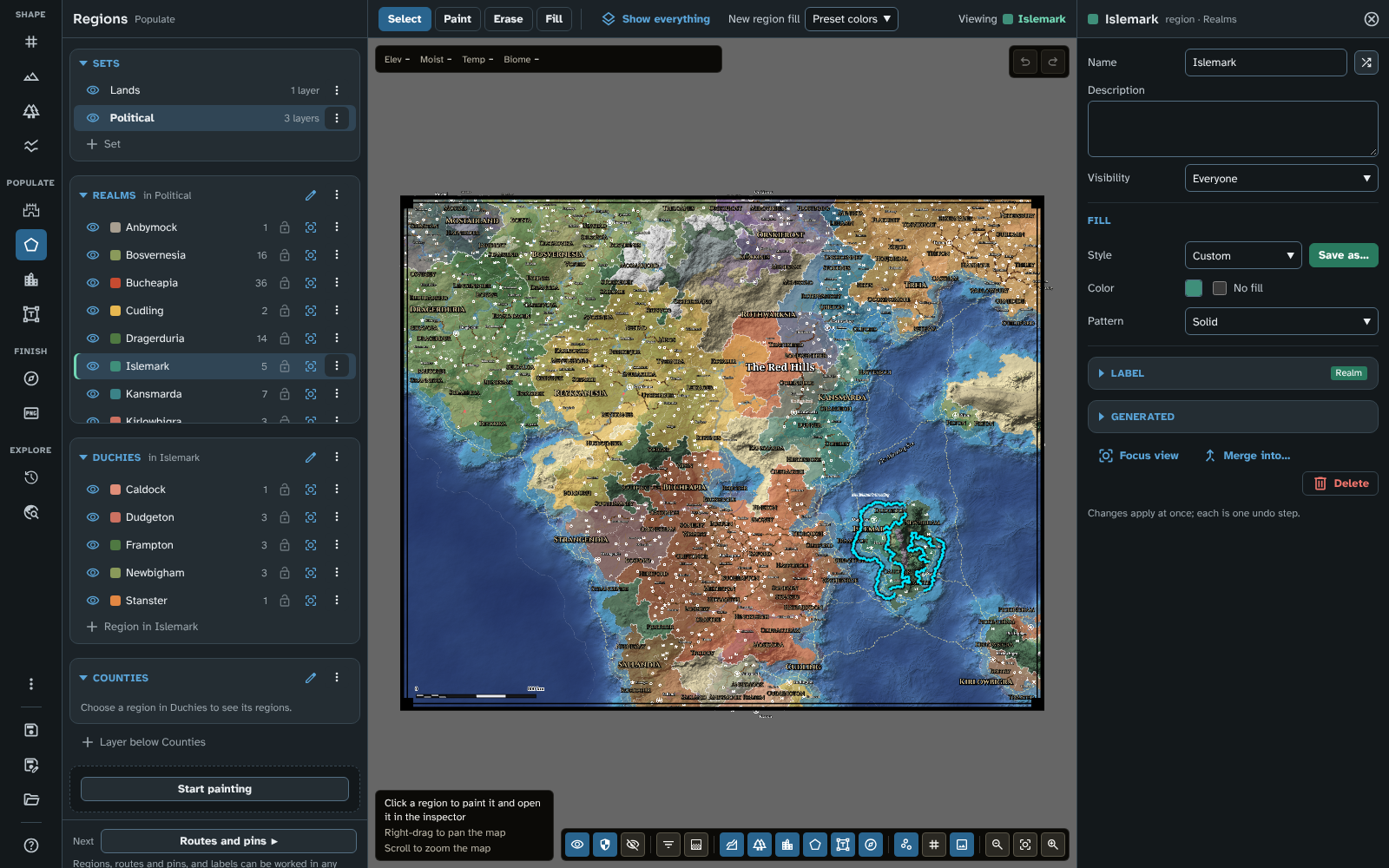
The studio on a finished map: Regions open, with the realm Islemark in the inspector.
Main features
The map builder makes a world in two parts: the land, worked out from a procedural model of terrain and climate, and the people who live on it, worked out by a generator that reads that land. You can edit both by hand, and both carry on into the regional maps you cut from the world, closer and closer in.
The land
- Procedural terrain: layered noise and geological stretch parameters shape the land from a seed, so the same seed always gives the same world. Relief shading brings out the hills, valleys and seabed, and the sea and lakes are drawn as water you can see into, with their own biomes on the bed.
- Four terrain engines: Advanced (tectonics), Guided, Flat and Legacy generation. Advanced (tectonics) lets tectonic plates decide where the continents lie, raising mountain ranges, trenches and mid-ocean ridges where they meet or part, while Guided builds the land inside shapes you draw (or random shapes it draws for you). Both give natural coastlines, continental shelves and deep oceans, and look the same at any map size.
- Climate and biomes: temperature follows the latitude and the height of the land, and moisture is carried by the wind, with rain shadows behind the mountains. Together they decide the biomes. Define biomes of your own with rules (ranges of height, moisture and temperature) and they appear wherever the climate matches, with the built-in biomes as a fallback and a preview of where your rules leave gaps.
- Rivers and lakes: rivers run downhill from sources placed by the climate, widening as tributaries join them, meandering across the plains and splitting into deltas at the sea. They pool into lakes until they overflow, and freeze with altitude and climate. Add sources of your own, move or remove the ones placed for you, and draw rivers of your own that follow the land along your line.
- Tectonic features: draw mountain ranges in three styles, subduction zones with their trenches and volcanic arcs, rift valleys, and hotspot chains of volcanic islands, shaped like the map's own land, that age from active volcanoes to eroded islands, atolls and seamounts. Each is shaped by the terrain it crosses, so it blends into the map.
- Non-destructive brushes: raise, lower, level, slope, smooth and roughen the terrain, or paint biomes, with a freehand brush. Strokes are saved as a history rather than as pixels, so they follow the map when it is rescaled or cut into regional maps, and a saved map stays very small.
The people
- A generator for the world's people: Generate reads the land (how many people it can feed, how hard it is to cross, how easy it is to defend) and in one run places capitals, cities, large towns, towns, castles, fortified towns and ports, traces the trade between them as roads, river trade routes and sea lanes, and divides the land into realms, duchies and counties. Everything is named, in 43 name styles, and each name stays put when other places come and go.
- Built round your own map: place a capital, city, port or castle pin and the run builds that settlement there; paint a realm, duchy or county and it keeps exactly that land, filled in round and inside; draw a road, sea route or river and the trade follows it.
- Influences: paint where the land should feed more or fewer people, or be safer or more dangerous (bandit country, a quiet heartland), and the next run follows the painting.
- Cultures: give the map peoples of its own, each with a habitat, homelands and a language. A culture's habitat comes from the biomes it is at home in, or from climate zones you set, so a forest people settles the forests wherever they grow. Cultures spread over the land that suits them, mix where they meet, name their own places and rule their own realms. A culture can invade, arrive, migrate or colonise in a later age.
- Ages and history: a generate run can pass through up to eight ages, from a dark age to an age of advancement, each with its own level of strife and with events (plagues, famines and disasters, civil wars, collapses and dynastic unions, trade booms and trade wars, some at a place you choose). Each age starts from the one before, and leaves ruins, abandoned castles, old roads and former capitals behind. The History tool shows the map as it was in each age, what changed between them, and exports any age as an image.
- Villages and market towns: on a regional map, Fill in adds the villages and market towns between the places it inherited and the settlement pins you place, joined to the roads by lanes. They share out the people of the world's run, so a fill-in never adds people the world did not have, and each closer regional map can be filled in again, more finely. A regional map carries its world's settings, influences and history with it.
- Thematic layers: colour the map by population, the land's capacity, cleared land, danger or culture, and draw the trade along its roads, rivers and sea lanes, to see why the run put things where it did.
- Travel times: the Travel tool shows how long journeys take from any place, on foot, by wagon or by fast mount, with boats and ships on the rivers and sea routes, as bands of days across the map, the time there and back, and the quickest way to the pointer. Climbs are slower than descents, ships sail faster with the wind, and winter closes the high passes and frozen seas.
- Yours to change: everything the generator makes is ordinary map content. Anything you edit or lock is kept when you generate again, and the inspector shows each place's population, cultures and history.
Making the map
- Regions painted on the map: paint regions onto the map's cells with a brush, fill and eraser, in layers (a kingdom's duchies inside the kingdom, and their counties inside them) grouped into layer sets. Each region claims the sea along its own coast, and each layer has its own borders, opacity and territorial waters.
- Routes that find their way: a route is a chain of waypoints, and the module finds the way between them over the terrain, so a road winds round the mountains and joins the roads already there, and a sea lane keeps to the water.
- Pins, labels and styles: pins, routes, labels and region fills each have named styles that set the look of everything using them, and Save as… makes a style from anything you have tuned. 29 fonts come with the module, and names are placed so they don't cover each other, the pins, the decorations or the map's border.
- Names for everything:
- Name natural features finds the map's oceans, seas, bays, lakes, mountains, hills, forests, deserts, plains and largest rivers from its terrain and names them in the language of the people living there, with each river's name following its course, as the rivers you draw have their names along them too.
- A Random name button beside every name so you can change any name quickly.
- Name all for the whole map, which names your own regions, places, routes and rivers the same way.
- Detail level: a world map can hold thousands of places, so the Detail menu shows as much as the map's scale suits, from capitals, cities and realms alone to every village and county, with a symbol size that grows on closer maps.
- Regional maps: cut any part of a map into a new map at a higher resolution, with finer coastlines, terrain and biome borders, and the parent's rivers, features, regions, places and routes carried in. Because the land is procedural, you can keep cutting closer, from a world towards a single valley.
- The inspector and mass edit: choose anything on the map, or its row in a list, and it opens beside the map. Changes apply at once, each is one step of undo, and mass edit changes many pins, routes, labels or regions together.
- Cartography: a scale bar true to the world's scale, a border, the grid, a compass rose and a cartouche drawn by the module (in three designs each, with colour schemes), and decorations of your own.
Sharing the map
- Export to a Foundry scene (Foundry module version only): every object and layer can be shown to everyone, to the GM only or to no one. The players' map becomes the scene's background, a tile over it holds what only the GM sees, and a journal with a page for each named place, route and region (with the generator's figures) is made so you can add your own detail about key locations. Each grid cell's biome, terrain, regions, places and routes are written onto the scene for other modules and game systems to read.
- Export image: export the map as you see it, as a PNG or a much smaller WebP, at a scale chosen so its smallest names can be read.
- The 3D view: see the map draped over its own terrain, with its water, rivers and light.
In Foundry and on the web
- One map builder, two homes: it runs as a module in Foundry VTT, and in any browser at fwmb.filroden.com, with the same tools in both. In Foundry, maps are saved as journals in a compendium; on the web, they are saved in your browser, with a backup of every map in one file. A map's JSON file moves it between the two, in either direction.
- Made to be read: four colour themes (light and dark, gold and teal) that meet the WCAG AA contrast levels, supports right-to-left languages, keyboard throughout the studio with a Help tool showing every shortcut, the version and links to the wiki.
Example maps
The map the tutorial builds, P0JBVA, at the end of its tenth page, exported as a PNG at its own size (2,000 × 1,600 pixels):
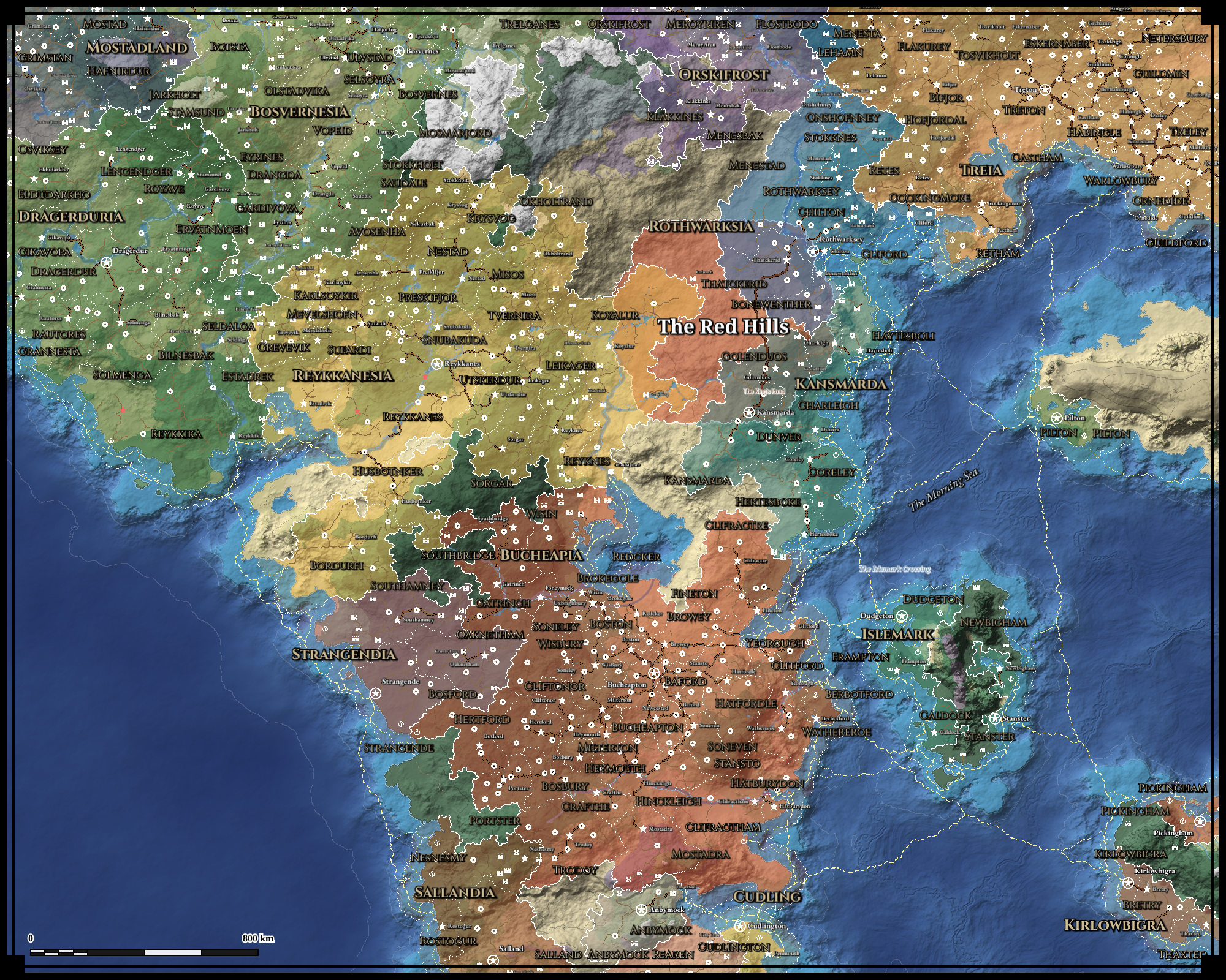
The tutorial's world map, P0JBVA.
Download its map file, 10-finishing-and-sharing.json, and import it in Maps with Import JSON.
A regional map of its Red Hills, cut at four times the detail and filled in with villages and market towns (1,600 × 1,760 pixels):
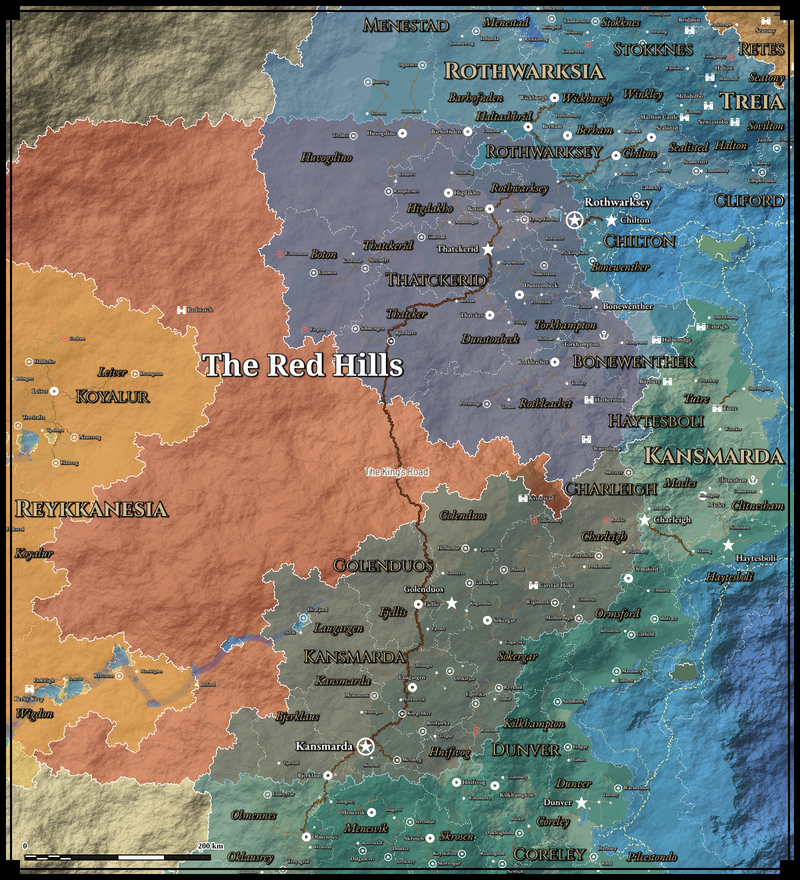
The tutorial's regional map of the Red Hills.
Its map file: 11-a-regional-map.json.
Find your way around this wiki
New to the module? The tutorial builds one complete map over twelve pages, using nearly every tool, with a map file at the start of each page so you can join it anywhere. Prefer to watch? The whole tutorial is also a 20-minute video, with a chapter for each page. Getting Started is the short version: the order of work for a mapping session, and why, with tips along the way. Used version 3? Where did it go lists where every moved control now lives.
Looking for how a part of the interface works? These pages follow the rail:
- Map Canvas: the map itself: panning, zooming, the information bar, the hint, undo and redo, and the map controls, including the detail level.
- Map Making Tools: how the studio works: the rail, the panel, the bar, the inspector, lists and mass edit.
- Shape
- New map: starting a map, choosing an engine, a Guided map's land masks, and regional maps.
- Terrain: the terrain's generation, shading and water, and the terrain brushes.
- Biomes: climate, moisture, biome colours, custom biomes and their rules, and the biome brush.
- Rivers and faults: rivers, lakes, custom rivers, tectonic features and hydrology.
- Populate
- Influences: painting where the land should feed more or fewer people, or be safer or more dangerous, to steer Generate.
- Generate: populating the map with settlements, routes and realms, through one or more ages and their events, building round your own pins, regions and routes, and keeping what you edit.
- Cultures: the map's peoples, the land they suit and the names they give.
- Regions: layer sets, layers, and painting regions.
- Routes and pins: pins, and routes found between waypoints.
- Labels: every label on the map, and labels of your own.
- Finish
- Cartography: the scale bar, border, grid and decorations.
- Export: image export and export to a Foundry scene.
- Explore
- History: the map as it was in its earlier ages, and what changed between them.
- Travel: how long journeys take from a place, on foot, by wagon or by fast mount, in each season.
- More tools
- Reference image: an image to trace over.
- Styles and icons: styles, pin icons, and sharing them with another map.
- Maps: saving, loading and sharing maps.
- Help: the version, links, shortcuts and acknowledgements.
- Module Settings: the Appearance menu, and the module's settings in Foundry.
- Grid Cell Data: the grid cell summary written onto an exported scene, for module and system developers.
- FAQ: common questions, and a note on performance at larger map sizes.
- Updating to 4.3.0: bringing a map made before version 4.3.0 up to date with its new features, step by step.
- Release notes: every feature, improvement and fix in each version from 3.0.0.