On this page
Part of Map Making Tools
Influences
The Influences tool steers Generate. Paint where the land should feed more or fewer people than Generate would make it, or be safer or more dangerous, and the next run follows the painting: richer land fills with people and towns, poorer land empties, and dangerous land loses people and gains walls and castles.
Influences are optional: Generate works without any. The painting is relative to what Generate works out, not a figure of its own ("more fertile here", "bandit country here"), so it keeps its meaning when the terrain, cultures or ages change, and nothing has to be on the map under the brush first.
Influences is the first tool of the Populate stage, before Generate. Next goes to Generate.
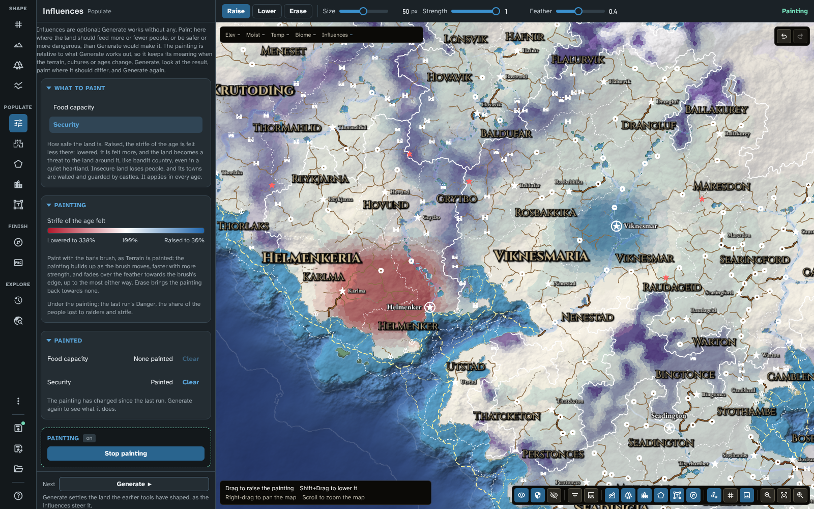
Security painted after a run: bandit country in the western hills, lowered in red, and a safer heartland round Viknesmar, raised in blue, over the run's Danger.
The loop
- Generate the map (see Generate).
- Look at what the run made: the Population, Capacity or Danger thematic layers show where it put the people and where it is unsafe (see Thematic layers).
- Open Influences and paint where the map should differ.
- Generate again, and see what the painting did.
Painting after a run marks it out of date in Generate, and undoing the painting clears it.
The panel
What to paint
- Food capacity: how many people the land feeds. Raise it where the land should be richer than Generate would make it, lower it where poorer, so more or fewer people live there and towns grow or shrink with them.
- Security: how safe the land is. Raised, the strife of the age is felt less there. Lowered, it is felt more, and the land becomes a threat to the land round it, like bandit country, even in a quiet heartland, fading with distance as wild land's threat does (a seat's protection still reduces it). Insecure land loses people, and its towns are walled and guarded by castles.
Both apply in every age.
Painting
A scale, from red (lowered to the least) through white (none) to blue (raised to the most), says what the painting does at each end and at none:
|
Lowered to the least |
None |
Raised to the most |
| Food capacity (people the land feeds) |
30% |
100% |
338% |
| Security (strife of the age felt) |
338% |
100% |
30% |
Below it, the panel says what the map shows under the painting (see The map).
Painted
Each kind says whether any of it is painted (Painted or None painted), with Clear, which asks first and then takes away all of that painting as one step of undo. A notice says when the painting has changed since the last run.
The bar
- Raise: more food, or safer. Shift+Drag lowers.
- Lower: less food, or more dangerous. Shift+Drag raises.
- Erase: brings the painting under the brush back towards none.
- Size, the brush's radius, shared with the other brushes.
- Strength (0.05 to 1, 0.25 to start): how quickly the painting builds up as the brush moves.
- Feather (0 to 0.9, 0.4 to start): how much of the brush paints at full strength; beyond it the stroke fades to nothing at the brush's edge.
The brush paints as the Terrain brushes do: the painting builds up as the brush moves, faster with more strength, up to the most either way, and fades over the feather towards the brush's edge, so it blends into the land round it. Raise and Lower paint land only; Erase works on land and water. Escape ends a stroke. Each stroke is one step of undo.
The map
While the tool is open, the painting is drawn over a layer that shows what it is steering, in the thematic layer's place:
- Food capacity over the last run's Capacity layer, how many people the land could feed. With no run, the land's capacity is worked out from the terrain, climate and rivers, as a run's first stage would, so it shows before you have ever generated ("Working out how many people the land could feed" while it does).
- Security over the last run's Danger layer. Danger comes from the realms, which Generate makes, so before a run the land shows no danger anywhere, with the painting over it.
The painting is tinted blue where raised and red where lowered, stronger the further it goes, and even the faintest painting shows. The layer under it is the run's as it was, without the painting applied: generate again to see what the painting does. Region fills are drawn as borders alone while the tool is open, so they do not hide the painting. The Opacity in the map controls' Thematic layers menu fades the overlay, and the menu says that the painting is shown while the tool is open.
The information bar gives what the painting does under the pointer ("Food capacity: feeds 160%", "Security: strife felt at 45%", or "Food capacity: none").
Regional maps
A regional map carries the painting of the map it was cut from over its area, and you can paint over it on the regional map's own cells. Its Fill in shares more of the parent's people onto land painted richer in food capacity (security has no part in a fill-in). See Fill in.
Tips
- Paint a little and generate again: food capacity raised to the most more than triples what the land feeds, which moves towns a long way round it.
- To make a haunted wood or a robber-infested pass, lower Security over it; to make a realm's heartland quiet, raise it.
- To change how the land behaves everywhere a biome grows (all marshes hard to farm, say), give a custom biome numbers of its own instead (see Biomes).
- The painting is saved with the map, and kept when the map is rescaled or its terrain's noise moved.
Next: Generate
Related: Generate, Map Canvas, Terrain