On this page
Part of Map Making Tools
Generate
The Generate tool populates your map in one run. It works out where people could live on the land you have shaped, then places capitals, cities, large towns, towns, castles, fortified towns and ports, links them with roads, river trade routes and sea lanes, and divides the land into realms, duchies and counties. Everything is named. A run can pass through several ages, so the map can have a history: ruins, abandoned castles, old roads and former capitals.
What Generate makes is ordinary map content. The realms, duchies and counties are regions in a layer set called Political (see Regions), the places are pins and the routes are routes (see Routes and pins), and their names are labels (see Labels). You can edit any of it afterwards with the other tools. When you generate again, what you edited or locked is kept and the rest is replaced.
Generate also builds round what you have put on the map yourself: a settlement pin becomes a settlement of its kind, a realm, duchy or county you drew in the Political set keeps exactly its land, and the roads, sea routes and river routes you drew carry the trade (see Your own pins, regions and routes). To steer it further, paint where the land should feed more or fewer people, or be safer or more dangerous, with Influences.
Generate is the second tool of the Populate stage, after Influences. Next goes to Regions.
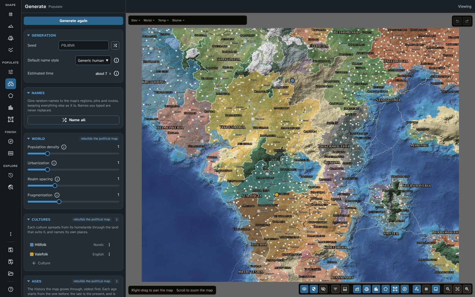
Generate after a run on the tutorial's world map, with its realms, roads and towns on the map.
How a run works
A run reads the map as it is: the land and sea, the height and ruggedness of the ground, the temperature and moisture, the biomes, the rivers and the coast. From these it works out, in stages:
- Reading the land: how many people each part of the land can feed (including changes to the food capacity painted in Influences), how hard it is to cross, and how easy it is to defend.
- Settling the peoples: where each culture lives (see Cultures).
- Founding the towns: first the settlements on your settlement pins, then cities, spaced across the land, then large towns and towns between them.
- Tracing the trade: the routes trade takes between the towns, by road, by river and by sea, along the routes you drew where they help. The busiest become trunk roads and main roads. A town trades by sea only where its own ground meets the sea or a lake, so ports stand on the water.
- Drawing the realms: the strongest cities become royal seats, and the land around each is divided among realms, duchies and counties, round the realms, duchies and counties you drew.
- Raising the castles: dangerous borders and passes gain castles, exposed towns gain walls, and trade gathers in the towns that are safe. Land painted more dangerous in Influences is a threat of its own, like bandit country.
- Settling the roads and fixing the borders: the trade and the realms are worked out again from the safer, busier map.
- Naming everything: places, realms and castles are named in their people's language. Each is named from its own place on the map, so a town keeps its name when other places come and go.
The run happens in the background. The map is covered while it runs, showing the stage, how far it has got, and a line saying what it is doing. Cancel stops the run and leaves the map as it was. The whole run is one step of undo.
The same seed and settings always give the same result on the same map.
How long a run takes
The panel's Estimated time is a guide for a typical computer. A run takes longer on a map that covers a larger area of the world (a wider span of latitude, or a larger area factor in New map), not on a map with more pixels. Each age adds about as long again. Above a minute, the panel says the run will take a while.
Small and regional maps
A run places towns at the spacing of a world map: cities a few hundred kilometres apart. A map that covers a small area (an island chain, or a regional map) gets only a few realms and the larger settlements, and the panel says so. A larger area factor in New map makes the world larger, with more of them.
A regional map cut from a map that was generated holds the parent's generated content, and a copy of the parent's run over its own area, with its earlier ages: its thematic layers show the parent's figures (see Thematic layers) and History shows its past. It also carries the parent's Generate settings (its world, ages and events, name style and output) and the influences painted over its area.
While a regional map holds its parent's run, Generate is off on it, and the Generation section's badge reads fill in only: a run made on the regional map alone, blind to the land beyond its edges, would not match its parent. The World and Ages sections are shown read only, each age opening in the inspector read only too. You have two choices:
- Fill in adds villages and market towns between the places the regional map inherited, and keeps everything it inherited (see Fill in).
- Clone as new on the regional map's card in Maps saves a copy as a map of its own. On the copy Generate is back, with the carried settings in use, and replaces the inherited content (except what you have edited or locked) with a run of its own, made for the regional map's own terrain.
A regional map with no copy of its parent's run, or whose parent map is gone, can be generated as it is.
The panel
Generate
The button at the top of the panel runs the generator. Once there is a run, it reads Generate again and asks first, saying how many realms, places and routes will be replaced and how many of your edited or locked items will be kept.
Generation
- Seed: what the settlements, routes and realms are made from. Left empty, the map's own seed is used (shown faintly in the field). The shuffle button (Generate random seed) picks a new one.
- Default name style: the language names sound like wherever no culture names them, from 43 styles: the whole map when it has no cultures, otherwise the land no culture holds. Generate, Fill in and Name all use it there.
- Estimated time (see How long a run takes).
The section's badge says out of date when something the last run read has changed since: the terrain, climate, rivers, area factor, cultures or ages, Generate's own settings, the routes, settlement pins and Political regions it built round, or the influences painted on the map. Generate again to bring the map up to date. A change to your routes, settlement pins, Political regions, drawn rivers, river sources, tectonic features, land masks or influences can be undone, and undoing it clears the badge; renaming or restyling them changes nothing.
On a map made before version 4.3.0 of the module, the badge reads older generator: the map keeps the older generator's rules (in Travel and Fill in too) until you generate again, which brings the current ones (see Updating to 4.3.0). On a regional map holding its parent's run it reads fill in only (see Small and regional maps).
Notices below it say when the map is small, when it holds content from its parent map, when the last run stopped before its last age, and when a culture's homeland was left out or placed for it. Settlement pins the last run could not build on are listed by reason (on water, on land too small, a port pin where ships cannot load, a capital pin that did not become a realm's seat, or no settlement could be placed), each heading with a tooltip saying why and the pins' names below it.
Fill in
Shown on a regional map. Fill in adds the villages and market towns that lie between the places the regional map inherited from its parent, and joins them to the inherited roads by lanes. Everything the regional map inherited stays as it is. The new places share out the people the parent's run put in the region, so filling in never adds people the parent didn't have, and more of them where food capacity is painted higher in Influences.
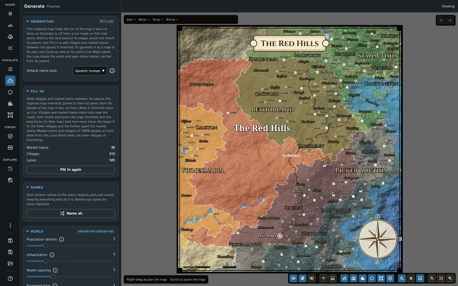
Fill in on a regional map at the Local detail level: the villages, market towns and lanes between the towns it inherited.
What a fill-in adds:
- Market towns fill the gaps between the inherited towns. Where people live more than half a day's walk from any town, the place with the most people round it becomes a market town, and so on until the gaps are filled. A market town holds a share of the people it serves, a few hundred to about a thousand.
- Villages: of the places where people farm, about one in as many as the map's area factor has a village (see New map): at the default of 15, about one in 15. They are picked by chance, but more often where more people live, so they gather in good country without falling into a pattern. A village holds the people of its own patch of land; the rest of the country people live in hamlets and farms, which are not shown. A village of 1,000 people or more is a large village.
- Lanes join each market town and village to the nearest road, town or lane, along the easiest way on foot, so lanes merge as they near a road.
- Names in the language of the people living there, none the same as a name already on the map. Each village and market town is named, and placed, from its own spot on the map, so filling in again keeps nearly every name and spot.
Settlement pins are places Fill in builds round (on a regional map of a map made or generated with version 4.3.0 or later), whether the parent's run made them or you placed them on either map: every pin in a settlement or castle style (Capital, City, Large town, Town, Fortified town, Port, Castle, Market town, Large village or Village), and the villages and market towns of an earlier fill-in you kept. Each holds its own people (its figures from a run, or else the least its kind holds: 15,000 for a city or capital, 4,000 for a large town, 1,500 for a town, fortified town or port, 1,000 for a large village, 300 for a market town, 100 for a village, and none for a castle), and no village or market town stands on it or beside it.
Where they stand:
- Near the roads: market towns and villages stand only within about 15 km, over land, of an inherited road, river route or town, and further round a big town, whose country feeds it: about 30 km round a town of 4,000 people or more, and 45 km round one of 15,000 or more. Further out, people live in hamlets and farms: even a track to the nearest road is a lot of work, so settlement follows the roads. A regional map with no inherited roads or towns has no such limit.
- Spaced by the area factor: the larger the map's area factor, the fewer villages and the further apart the market towns, in step with how the area factor thins out everything else (see New map).
- Out of the rivers: places keep clear of the rivers as the map draws them, however wide.
They use the map's Market town, Large village and Village pin styles and its Lane route style, added from the defaults when the map lacks them (see Styles and icons). Market towns and large villages show from the Local detail level, and the other villages at Everything (see Detail level). After a fill-in, the map shows the most detailed level at which its new places aren't crowded.
Fill in works in the background, with the map covered and Cancel to stop, and is one step of undo. Afterwards the section counts the Market towns, Villages and Lanes the last fill-in added, and the button reads Fill in again. Filling in again asks first, then replaces what the last fill-in added, except what you have edited or locked. What the map inherited is never touched.
The section's badge says out of date when what the last fill-in built round has changed since: its settlement pins (moved, added or deleted), the routes or the food capacity painted in Influences. Fill in again to bring it up to date, or undo the change.
Filled-in places and lanes are generated content: they have a Generated section in the inspector, can be locked, and Generate or Remove generated content replaces or removes them like the rest. A regional map cut from a filled-in map carries its villages, market towns and lanes as inherited content, so it can be filled in again, more finely.
When it is offered: once the regional map shows its world closely enough, which is when the parent's generator cells (about 25 km apart) lie at least 30 pixels apart on it. Further out, the section says to cut a regional map closer in. A regional map cut before regional maps kept their parent's run gets a copy when it is opened, if its parent is saved and still holds the run its content came from; otherwise the section says to cut it again.
At cut: Fill in villages and market towns in New map's Regional map section fills in the new regional map the first time you open it (see New map).
Names
Name all gives random names to the map's regions, pins and routes, and changes nothing else. It opens a dialogue with two groups of ticks:
- Name: Regions, Pins and Routes. Regions and pins are ticked at first. Routes are not, since a generated map's roads have no names, and naming them all would label thousands of roads.
- Replacing: which names are replaced: No name, Random names, Default names such as "Region 2" (and "Route", or a pin named after its style or icon), and Generated names you have not edited. All but generated names are ticked at first.
The line below says how many items the ticks would name ("Names 849 items."), and Confirm is greyed out while they would name none. Names you typed are never replaced, and river sources are never named.
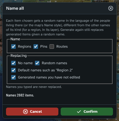
The Name all dialogue, with the number of items it will name.
Each item gets a name in the language of the people living there (or the map's Default name style), different from the other names of its kind (for a region, from the other regions of its layer). About one name in three adds a word that fits the item: a region's land (Isle, Mountains, Hills, Coast, Forest, Plains and so on) or, in a top layer, a realm's form of the name ("Ashfordia"); a pin's kind of place (Castle, Keep, Port, Haven, Market, Old); a route's transport (Road, Way, Reach, Crossing, Passage). Name all is one step of undo.
A random name doesn't count as an edit, so Generate again still replaces a generated item that has one (see Generate again: what is kept). The Random name button beside a pin's, route's or region's Name in its inspector does the same for one item (see Routes and pins and Regions).
The map's seas, mountains, forests and rivers are named by Name natural features in the Labels tool.
World
The badge says rebuilds the political map. Each slider is a multiple of the usual, so 1 is the default. Double-click a slider to put it back to 1.
- Population density: how many people the land feeds. Higher values give more and larger settlements.
- Urbanisation: the share of people living in towns and cities. Higher values give larger towns and busier roads.
- Realm spacing: how far apart royal seats must be. Higher values give fewer, larger realms; lower values more, smaller ones.
- Fragmentation: how far a lord's wealth carries his rule. Above 1 the map breaks into more, smaller duchies and realms; below 1 fewer, larger ones hold together.
Cultures
The map's peoples, each with its own habitat, homelands and name style. See Cultures.
Ages
The history the map grows through, oldest first. The last age is the present, and is what the map shows. A new map has one age.
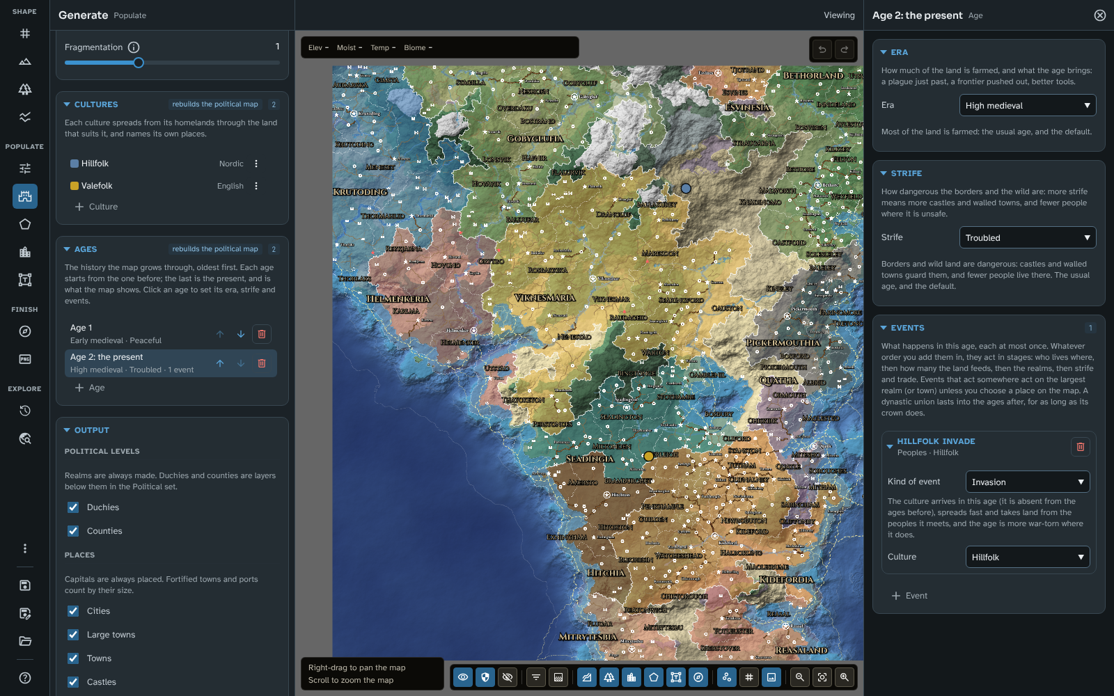
The Ages list: an early medieval age of peace, then the present, troubled, open in the inspector with the Hillfolk invading.
Each age is a row: its name over its era, its strife and how many events it has. Click a row to open the age in the inspector. The buttons on each row move it earlier or later, or remove it (at least one age remains). + Age adds a copy of the present's era and strife, with no events, after it, which becomes the new present, and opens it. A map can have up to eight ages. Every change to an age is one step of undo.
The age inspector has three sections:
- Era: how much of the land is farmed, and what the age brings, with what the chosen era does below it:
- Dark age: little of the land is farmed, towns are few and small, and realms break into many small ones. It leaves many ruins.
- Early medieval: less than half the land is farmed, so fewer people and smaller towns than later ages.
- High medieval: most of the land is farmed. The usual age, and the default.
- Age of expansion: settlers push into marginal land (land growing less than the median), which feeds up to nearly twice as many, so the frontier fills with farms and towns.
- Age of advancement: better farming, tools and boats: land and sea feed a third more people, with more and bigger towns.
- After a great plague: a great plague has just taken a third of the people, and the survivors farm the best land.
- Strife: how dangerous the borders and the wild are: Peaceful, Troubled or War-torn. More strife means more castles and walled towns, and fewer people where it is unsafe.
- Events: what happens in the age, each kind at most once. + Event adds one; each event is a folding group named by what it is ("Hillfolk invade", "Civil war"), with a line in brief below its name and Remove event. Its Kind of event is chosen from four groups, largest in scale first:
- Peoples (shown while the map has cultures, which are added in the Cultures section above), each naming a Culture, which is absent from the ages before:
- Invasion: the culture spreads fast and takes land from the peoples it meets, and the age is more war-torn where it does.
- Arrival: the culture settles where it fits best, taking land as it spreads.
- Migration: the culture settles among the peoples already there rather than taking their land.
- Colonisation: the culture starts from the best empty land no realm held, and spreads slowly into land realms hold.
- Hardship:
- Plague: takes a third more of the people, on top of any the era brings. It leaves ruins.
- Famine: the land feeds a tenth fewer everywhere, and up to half fewer on marginal land.
- Disaster: a flood, eruption or earthquake wrecks the land within 50 km of its place, and no town stands at its heart.
- Realms:
- Collapse: the realm's duchies stand alone as independent realms, and strife rises in its land.
- Civil war: the realm splits between two rival crowns, and strife rises in its land.
- Dynastic union: the realm absorbs its strongest neighbour (across the sea, for an island realm) by marriage or inheritance, and keeps it in the ages after, for as long as its crown lasts. A realm you drew yourself keeps exactly its land, so it neither absorbs nor is absorbed.
- Prosperity:
- Trade boom: trade doubles, with more townspeople, bigger trading cities and busier routes.
- Trade war: trade between realms dwindles to a quarter and crossing their borders costs more.
An event's place: a disaster, a realm event and a trade war act somewhere. Unless you choose a place, a disaster strikes the largest coastal or river town, a realm event acts on the largest realm, and a trade war acts between all realms. Choose on map, then click land, to choose the place (the button reads Click the map while it waits; Escape stops). A realm event acts on the realm holding the place, or the realm nearest it; a disaster centres on it; a trade war is then only between that realm and the rest. Clear the place goes back to the default. The place is marked in red on the map while the Generate tool is open. After a run, the event says what it acts on as the map shows it ("In Bucheapia", "The largest realm (Bucheapia)"); in the ages before the present, whose realms the map does not show, it says only what it falls back to.
Realms and towns come from a run, so on a map with no run yet the Events section says to generate once, look at the realms, then add the event, choose its place and generate again.
The order of events: whatever order you add them in, an age's events act in stages: who lives where, then how many the land feeds, then the realms, then strife and trade. So a famine and a civil war in the same age give the same run in either order. An age saved before version 4.3.0 with one event reads it as a list of one.
Each age starts from the one before:
- Land farmed in the age before farms better.
- Towns tend to grow where towns stood before, so most places carry on, and keep their names. What changes them is what the new age changes: a plague, a different era, more strife, a culture arriving.
- The roads and sea lanes of the age before are already there, so trade starts from them.
- Kingdoms keep their royal seats where the seat's town survives, so a realm carries on, or breaks up where its seat fell.
What the age before the present leaves on the map (when Ruins and old roads is on in Output):
- Ruins: towns of that age with no town on their ground now. A ruin is named as its people named it then (perhaps in another culture's language) and drawn in its own style: the icon of what it was (a star for a city, say), in red. Its details say what it was ("City in age 1, 31,653 people").
- Abandoned castles, in the Abandoned castle style.
- Old roads: roads that carried that age's trade and carry none now, dashed in the Old road style.
- Former capitals: a place that was a realm's seat then and is not now keeps its own style, with "(former capital)" after its name. A ruined capital has its own style, Ruined capital.
Every earlier age is kept with the map's run, and the History tool shows the map as it was in each, with what changed between them. Each place's details give its history through all the ages ("Town in ages 1–2 · City since age 3").
Stopping a long run: once an age has finished, the overlay offers Keep finished ages beside Cancel. It stops the run and places the ages already finished, with the latest of them as the present. The panel then says how many ages the last run made.
Output
What a run writes onto the map:
- Political levels: realms are always made. Duchies and Counties add the layers below them in the Political set (Counties needs Duchies). Realms are filled; duchies are drawn as dashed borders and counties as dotted ones, each shown with its names from its detail level (see Detail level).
- Places: capitals are always placed. Cities, Large towns, Towns and Castles can each be left out. Fortified towns and ports count by their size.
- Routes: Roads, River trade and Sea lanes. River trade follows the rivers as the map draws them.
- History (shown with more than one age): Ruins and old roads, what the age before the present leaves on the map.
- Names: Show names shows the names of the places, regions and routes the run makes, each from its style's name detail level (see Detail level). Off, everything is still named, with its label hidden.
- Styles: Use the default styles sets the pin, label and route styles that generated content uses back to the module's defaults before the run, keeping their names, and restyles everything that follows them. It starts on when the map's styles come from an earlier version and suit a different scale.
A run uses the map's pin styles for each kind of place (Capital, City, Large town and so on), its route styles for each transport and class (Trunk road, Main road, River trade, Sea lane and so on) and its label styles for each kind of name (Realm, Duchy, County, Capital, Settlement). A style the map lacks is added from the defaults. See Styles and icons.
Results
Shown after a run: how many realms, duchies, counties, capitals, cities, towns, castles, roads, river trade routes and sea lanes the last run left on the map, with ruins, abandoned castles and old roads counted apart, the Settlement pins built on, the population, and each culture's share of it.
Remove generated content
Shown while the map holds generated content. After asking, it removes everything Generate made, except what you have edited or locked. Your own settlement pins and regions stay, without the figures the run gave them. One step of undo.
Your own pins, regions and routes
A run builds round what you have placed on the map yourself: your settlement pins and routes in every age, and your Political regions in the present.
Settlement pins
Every pin whose style is a settlement's (Capital, City, Large town, Town, Fortified town, Port or Castle) is a place the run must build on, whether you placed it or kept it from an earlier run (edited or locked). The run places a settlement of that kind there before the others, keeps it whatever its spacing and however few people its land feeds, and never lets it fall below its kind:
- a Capital pin is the seat of a realm;
- a Castle pin is a castle, a Fortified town pin is walled;
- a Port pin is a port, where its ground meets the sea or a lake;
- a settlement in a poor place (a city in a desert, say) lives by trade: it draws what it lacks of its kind's least from the trade, so the townspeople in all stay what trade supports;
- a pin dropped just off the shore is built on the land beside it.
Market town, village, ruin and other pins are not built on by a world run (Fill in builds round villages and market towns on a regional map). A city with no realm reaching it stands alone as a city-state, as a generated one would.
The run never moves, renames or restyles your pin and puts no second pin beside it. It writes what it made there into the pin's Generated section, read only: the kind of place, its population, cultures and history, whether it is a capital, walled or a port. A kept generated pin has its figures brought up to date and keeps its name, place and style. Pins the run could not build on are listed in the Generation section (see Generation).
Regions in the Political set
The realms, duchies and counties in the Political set that a run keeps (those you drew, and generated ones you edited or locked, with the rest of their realm) are built round in the present age, and each keeps exactly its painted land:
- A realm you drew holds its land, and the run fills it with its own duchies and counties where you drew none, crowned at a capital pin inside it, or else its richest duchy's seat. No other realm is crowned inside it, and no generated realm crosses its border.
- A duchy you drew holds the counties inside it.
- A duchy in no realm of yours, or a county in no duchy or realm of yours, follows its Independent choice in the region inspector: ticked, it is a state of its own; unticked (the default), the run treats it as one of its own, so a realm may take it whole (or a duchy, for a county), but never cut through it.
Only regions in the Political set count. Regions drawn before the map had a run sit in a set of your own; Move to Political set… moves them in (see Regions). The run writes what it made of each region into its Generated section, read only, as for a pin.
Routes
Every route you drew, and every generated route you kept, carries trade in every age: a road is a road on the land it crosses, a sea route a sea lane, and a river route a navigable river (even one drawn over land, which cultures and realms then spread along, as along a river). A route's class does not change how much it carries. The run lays no road of its own along them, and the Trade thematic layer draws their trade along their lines (see Thematic layers). Fill in on a regional map does not read them.
Generate again: what is kept
Generating again replaces what earlier runs made, so you can try other settings or seeds. What you have worked on is kept:
- Edited: anything generated that you change in a way that matters: rename, describe or move it, repaint a region, reshape a route, or give it a look of its own in its inspector. Changing a style that it follows, its label or its visibility doesn't count, nor does a random name (from Random name or Name all); typing a name does.
- Locked: anything you lock, edited or not.
- Regions keep their whole realm: a kept county keeps its duchy and realm with it.
- Everything you made by hand is never touched.
The new run fits round what you kept: no new place is put where a kept one stands, and new regions take only the land no kept region holds.
Locking: generated rows in the Pins, Routes and Regions lists have a lock button beside Focus view, and the inspector's Generated section has a Lock switch. Each is one step of undo.
Generated details in the inspector
Everything a run makes has a Generated section in its inspector (folded at first). It shows, as they apply:
- Place: what it is (Capital, City, Large town, Ruined city and so on), its Population, its Cultures (the peoples living there, over 5%), its History through the ages, when it was a Former capital, and for a ruin what it was (Formerly).
- Region: its Title ("Kingdom of Ashford"), its Rank (Kingdom or Independent duchy), Population, Cultures or Culture, its Ruling culture (for a realm: the culture of the people at its capital), and how many Duchies and Counties it holds.
- Route: its Kind (Road, River, Sea or Old road) and Class (Trunk, Main or Minor).
- Shown from (and Name shown from, when its name appears at a more detailed level than the place): the detail levels it appears at (see Detail level).
- Generate again: what generating again will do with it: Kept (edited), Kept (locked), Kept with its realm or Replaced. For your own settlement pin, Built on (your settlement pin), and for your own region, Built round (your region).
- Lock (not for your own pins and regions, which a run never replaces).
In Foundry, exporting the map to a scene makes a journal page, with these figures, for each generated place, route and region whose name the map shows at its detail level (see Export).
Tips
- Shape the land first: Generate reads the terrain, biomes and rivers, so changing them afterwards marks the run out of date.
- Set the Detail level in the map controls to thin out a crowded world map (see Map Canvas). A run starts the map at the level that suits its scale.
- To see where the run put its people, choose Population in the map controls' Thematic layers menu (see Thematic layers).
- Try a few seeds with the same settings: each gives a different but equally plausible world.
- To add villages to a region, cut a regional map close in, with Fill in villages and market towns ticked, and step the Detail menu from Regional to Local to Everything to see them arrive.
- Lock the realms and cities you like before trying other settings.
- To put a city where you want it, place a pin in the City style there before you generate: the run builds the city on it and the towns and roads round it.
- To steer where people live and where it is dangerous, paint Influences, then generate again.
- To make the land behave differently for the generator (a haunted wood that is hard to cross, say), give a custom biome Behaves like, or numbers of its own for Farming, Open ground, Travel cost and Raider risk (see Biomes).
Next: Regions
Related: Influences, Cultures, History, Regions, Routes and pins, Labels, Styles and icons, Map Canvas